Borderlands Traverse started out simple. After selling my newspapers due to the death of my business partner I was determined not to rush into anything new without some thought. Doing something too fast smelled like love on the rebound. I wanted no part of that. Better to wait and let the pain ooze out and the blood settle and coagulate. But, wouldn't you know it, while I was waiting I started to tidy up my home office. I ran across an old IDEA file -- dangerous buggers, those. There was a piece of yellowing paper stashed between other obvious loosing propositions with one sentence on it: "Walk the borders of a square state."
Technically there aren't any square states. Wyoming and Colorado are the closest contenders and both are more rectangular than square. But I knew what I meant when I wrote that sentence, one of the rare times of such clarity. We've got these straight lines on our maps which are really tokens of ignorance. I could expand on that thought but then I would get off-track with where I'm trying to go.
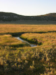
That single sentence signified an early experience of mine. Sitting in the back seat of our '48 Chevrolet crossing the border between Utah and Wyoming, age seven, expecting to see a straight line inked on the ground, maybe with abbreviations: UT on that side and WYO on the other. But of course there was nothing resembling a straight line, just rolling foothills of sage and some distance away, aspens and pines, fir; spruce higher up.
I don't think I felt disappointed but I know I felt lied to, deceived, and angry in a seven-year-old way. The maps collected, hoarded and stored in my treasure drawer - maps of magic with mysterious mountains, deserts and forests - did not tell the truth. I was morose and uninterested for almost a full week.
If my father had been alert and had lived any part of his life in his mind he might have recognized my distress. He was my idol, a war hero of mysterious accomplishments in Burma, an athletic man of grace who easily bowled over 220 in every game I ever watched, skied with the composure of a swan, swam with power and crispness, was fearless and competent in the face of nature and night sweats. I idolized him deeply and respected his few words and cautious, thoughtful approach to my questions. It took many years to realize that the answers came without a deep reservoir of contemplated connection. It may also be that they did, and that I remain merely ignorant of his Way.
"Is this the border?"
"Yep."
"Why can't we see it?"
"See the border?"
"Yeah, where is the line? There is a line on the map. I don't see any line."
"That line is so you can tell the border on a map. There isn't a real line. How would you make a line like that out there?"
I had no idea how I or anyone else would make a line 'out there.' But I promised myself that one day I would take my map and try to walk the line that some liar drew on my maps to see what the heck was supposed to be divided by that line. That is what that sentence in the IDEA file was all about.
It could have been a secret project. I didn't need to tell anyone about it. But I unfortunately am cursed with BIG IDEAS too often. And this, in rather quick fashion became one of those. I would start a blog, recruit school classes to follow the trek, send articles to the local papers, recruit a sponsor, talk interesting people into walking with me, write a book about it, become famous, go on a lecture tour, use the experience for launching myself. After all, I didn't have a real job anymore.
I talked to friends, or at least they started out as friends, and, puffed up and excited as only an aging Aries can be, painted wildly exciting and optimistic pictures of a Lewis & Clark-like venture taken up by thousands of co-conspirators who would all write wonderful essays of their experiences, take blindingly beautiful pictures and video and all of this would be a new sort of journalism.
My model was William Least Heat Moon, who did none of the stupid parts of this but did manage to do a deep mapping of a single Kansas County that occupies a full eighth of my heart, even though Kansas is not part of my own geographical imperative.
The obvious is cruelly apparent. My project is an abject failure. In the end, I didn't even choose a "square" state, although there were many reasons that made Utah, with its six straight-line borders more interesting than either Colorado or Wyoming.
No one else apparently wants to try to walk the stupidly straight borders of any state or country, marking way-points with their GPS units, taking pictures, telling stories. Geocachers, who I thought might be tempted, are more interested in finding "treasures" by coordinate, which is probably an entirely incorrect characterization since I can't say with any certainty that any ever heard of BorderWalking, Border Traverse or any of the other blogs associated with this Cervantean pipe dream.
So I am admitting the state of reality. This blog and its two sisters will go into stasis. I can't yet totally kill them. I'm not strong enough for that. Yet. I may even add to them from time to time or transfer some content. Who knows?
I don't, and that is really the point of this post. I'm going to camp for a while and see what turns up. If you have read this far though, please feel free to wander back along my trail thus far. I have walked some straight lines. And told some stories.