It’s just a guess but I’m betting most people who track this site or decide to participate by walking and reporting on some borderlands areas are map freaks. What can be better than a good map? So any info on various map types would be a welcome addition.
You don’t have to be a veteran map freak to know that there are maps that can give you all kinds of information, show not just where you are but what you’re seeing. Of course, the right map for the right job is a good idea. I only mention this because my geologist father-in-law often tries to navigate with his geology maps when we are on road trips. We have had near-death experiences looking for "the road that goes through this Ordivician outcrop."
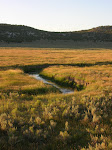
I mentioned “Ecoregions” in an earlier post. At first glance Ecoregions appear to have similar boundaries with topographic groupings – where the boundary line is drawn to group similar topographic features.
Ecoregions, as the name obviously suggests, group by ecosystem similarities and include things like plant and animal life, soils and also topological features that together have connected impacts on a localized area’s unique existence. The Environmental Protection Agency uses these spatial boundaries to direct and monitor research and actions that affect the environment.
There is an obvious and stark contrast to anyone who walks the state borders between those often straight-line borders and the borders of ecoregions.
Here is the main link to Ecoregion Maps in pdf format. Note that print versions are available.
State Ecoregion Maps
Colorado
Idaho
Nevada
Utah
Wyoming

Twitter Weekly Updates for 2012-08-26
-
RSVP form now updated for 2012-13! Great events planned for Past Tense
@TheHuntington Thanks to @USC_EMSI & ICW http://t.co/Xi4aimwf # Powered by
Twitter T...
13 years ago


